Late last year I was communicating with Udo (my roommate from the Cross Country Challenge) and he told me about riding the Pyrenees with PC and Ingun. Udo has passed away, but I am looking forward to doing this challenging ride. This ride is a Randonee (ultra-marathon events governed by a French organization). In my early cycling days I would dream about doing one of these like Paris - Brest - Paris, a 1,200 km event, but as the years passed, I let that dream fade away. I guess I've lucked into trying one of these events.
I will be riding with a German tour group - http://www.velotravel.de/velotravel/Reiseziele/Pyreneen/body_pyreneen.html
I hope you enjoy following my adventure. - Russ
The following is a Google translation from their website.
The "Raid Pyreneen" is a 714 km long "Randonée" over the main ridge of the Pyrenees. It connects the cities of Hendaye, on antlantic and Cerbere on the Mediterranean. The route passes through many famous passes that many times were at the Tour de France program. Col de Aubisque, Tourmalet and Col de Aspin are some of the best known.He also goes beyond fantastic and mostly traffic-free routes, and through the beautiful landscapes of the French Pyrenees. The aim of this Randonee is to cover the entire distance in less than 100 hours. A control card must be stamped at several places. As proof of performance to get the official diploma of Cyclo Club Bernais who supports this route since the 1950s.
Our tour is designed so that the bike every day with a journey time of about 6-7 hours, and an average speed of about 20 km / h can be well laid back. The last day is mostly flat, and has a journey time of just 3 hours. Overall, it is about 730 km, to overcome 18 passes and 11,900 vertical meters.
Each participant will receive a detailed route description. The meeting point is in each case the nearest hotel. Thus, driving each his own kick. While the tour is always our support vehicle nearby, which transports the luggage. This is, of course, can also be reached by phone, if the move should give greater problems once. You may go to change clothes, spare parts and tools, as well as drinks, fruit and energy bars. If you want to, or do not care for the "100 hours diploma", you can also climb, and a part of the distance to travel on the bus.
ITINERARY . 1 Day (SA): bus Karlsruhe- Hendaye We drive morning at Karlsruhe main station from. You have the option of your vehicle in the car park of the station turn off. Furthermore, there is also free parking near the station. Your bike is transported in our bike trailer, the special shots for racing bikes has (fork and rear wheel). In the area of Tours (or after about 850-900km route) we insert a overnight regroup. .
2 Day (SO): Arrival Hendaye morning drive towards the Pyrenees; In the afternoon we arrive in Hendaye. We have the late afternoon and evening, in order to recover some of the trip, by watching the bike again, to stroll through the city and prepare for tomorrow. The hotel stands us upon arrival of our bus available. Dinner at the hotel. .
3 Day (Mon): Hendaye - Gurmencon from 09:00 to 10:00 we leave the hotel and start to our first stage. The slightly later start, remains for us on Saturday until 14:00, to achieve the goal in Cerbere. A few kilometers after leaving the Hendaye route the Atlantic coast and heads inland. After the first small pass, the Col St. Ignace (169 m) we reach shortly the Spanish border. Next on the Col Pinodeila (176 m), we come to the small streets for the first control point in Espelette. Then there is still the Col d'Osquich (500 m, max. 8%) to overcome before we arrive in Gurmencon late afternoon. Dinner at the hotel. Length of about 175 km, 1.700HM, driving time 6-7 hours. .
4 Day (DI): Gurmencon - St. Marie-de-Campan After we could einradeln us yesterday, it's up early today. The famous passes of the Pyrenees are on the program. First, it is approximately 15 km quite moderate uphill to the Col de Marie Blanque (1035m). In a departure and a flat road to the checkpoint in Laruns we can recover before the ascent to the Col d'Aubisque (1709 m) begins, the partially has a gradient of 13%. After the Col de Soulor (1464 m) is reached quickly, and it goes downhill to Argeles. Another piece, and the feet of the next pass is reached. The Col de Tourmalet (2115 m), the king of the Pyrenees, still stands on the program. Another 18 km by initially moderate slope of 6-10% to be overcome. The last three hundred meters to the highest pass of the tour will have to be brought forward and fought for. Here, the pitch increases to about 18%. After a breather at the pass, and a descent of 17 kilometers, our next overnight point is reached. Length approximately 153km, 4.050HM, takes about 6.5 - 7.5 hours.
Day 5 (MI) St.Marie-de-Campan- Massat
Two large increases are to go back today. First, it is 13 km uphill to the Col d'Aspin (1489 m), after a steep descent continues up to the Col de Peyresourde (1569 m).Another long and fast descent and we reach Bagneres de Luchon and a longer flat track where we can recover. The Col des Arres (797 m) is made quickly and we reach the foot of the Col de Portet d'Aspet (1069 m). Here is the monument of Fabio Carsatelli, the Olympic champion from 1992, in 1995 was killed here during the Tour de France. This pass it again in itself!With a slope of partially nearly 20% we must again give everything before we can tackle the deserved descent to the next checkpoint, in St. Giront.Still further 25 km flat course and we reach our current endpoint and our hotel in Massat.
Length of about 175 km, 3.050HM, driving time approx. 7 - 8 hours .
6 Day (DO) Massat - Prades The Col de Caougnous (947 m) and the Col de Port (1249 m) are two smaller passes us not cause major problems, and leading a small lonely road. A beautiful descent leads to Tarascon where we reach for the first time a major road, which we follow the farther than 30 km to Ax-les-Thermes. After the 27 km long ascent to the Col de Puymorens (1915 m), another infamous passport of the Tour de France begins. We cycling past the border of Andorra and reach this windy exposed passport. Until Puiggcerda it goes down to about 1200m altitude. Now follow closely spaced Col de Lious (1345 m), Col de Rigat (1488 m) Col de la Perche (1507 m) and Mt Louis (1585 m). With the knowledge that we have the whole Pyrenees crossed here, and that now are facing a descent of nearly 60 kilometers, we can up here are excited about our achievements of the past days. Length of about 170 km, 3.100HM, takes about 6 - 7.5 hours .
7 Day (FR) Prades - Cerbere The next track is completely flat, and after some 30 km we reach in Argeles sur Mer Mediterranean. Along the coast to Port Vendres and Banyules s. Mer again over a few short ascents until we finally reach our destination Cerbere shortly before the Spanish border. We have the Pyenees crosses in less than 100 hours., can take a dip in the Mediterranean. After a brief stay in Cerbere, we go in the afternoon with the accompanying bus next to Carpentras (about 320 km) to the foot of the Ventoux. Length 88 km, 500HM, takes 2.5 - 3 hours.
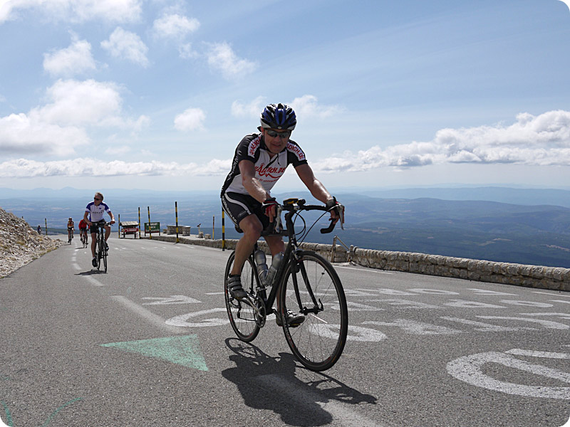
8 Day (SA) Mont Ventoux We have the whole day to the Ventoux, the climb "King of Provence". From Carpentras from, it's approximately 15 km mostly flat to Bédoin. Here the heavy ascent begins to Ventoux. It is 1,640 meters up a good 20 kilometers to deal with. After the summit, with 1.912m we reach about Malaucène again our starting point and our hotel in Carpentras. Length approx 85km, 2.000HM, takes about 5 hours. .
9 Day (SO) Return Carpentras Karlsruhe Early in the morning we start our return trip home. Around 19:00 we reach Karlsruhe (Track length 800 km).
This looks like a great ride. Come home in one piece.
ReplyDeleteAnne
This looks like an exciting ride, wish I was there. Thanks for your blog updates! Have a safe ride!
ReplyDeleteThis looks like an exciting ride, wish I was there. Thanks for your blog updates! Have a safe ride!
ReplyDelete